Mt. Julian and Terra Tomah Mountain
by Gordon S. Novak Jr.
July 7-9, 2003
|
Mt. Julian and Terra Tomah are easy to see
-- directly across from
the Forest Canyon Overlook on Trail Ridge Road -- but hard to get to.
I've tried several times to climb them, but failed each time.
There are two basic routes to Terra Tomah that are described in the
guidebooks, both unsatisfactory. One route is to descend directly
from Forest Canyon Overlook, cross the Big Thompson River, wade through
dense forest on the canyon floor, and ascend a ridge to the summit.
This route is unsuitable for a solo climber: the river crossing may be
difficult and dangerous, and the dense forest is not a good place to
be should one become injured and the subject of a search.
|  |
|
The other route the guidebooks describe is to approach Terra Tomah from
Mt. Ida. This route requires climbing Mt. Ida, then Chief Cheley and
Cracktop, then crossing a difficult and
exposed ridge to Mt. Julian,
and finally an easy walk from Julian to Terra Tomah. Then one must
retrace steps to get home, making nine mountains climbed in one day:
a Herculean feat. When I tried this route last year, I turned around
at 3:00 PM, still struggling with the ridge between Cracktop and Julian.
I had enough energy for five mountains, but not for nine.
|  |
|
Although I failed to climb Mt. Julian and Terra Tomah last year, I did
spot what looked like a viable route. South of Cracktop is a broad and
relatively flat glacial basin that provides access to the talus slopes
on the south side of Julian. The west side of the basin is a glacial
cirque with steep, corniced snow up to the Continental Divide, making
access to the basin difficult. However,
there is a small peak on the Divide, which I will call
"Triangle Peak".
whose northeast slopes allow access to the basin, avoiding the steep
snow. Gerry Roach's book alludes to a similar route in the "divide
traverses" section. My plan is to approach Triangle Peak from the
Haynach Lakes, hopefully reaching the divide early enough to complete
the climb.
|  |
The camp site for Haynach Lakes is taken, having been mentioned in a
magazine article, but by waiting until near the date I am able to get
a permit for the Haynach Llama site. Unfortunately, I will be both
hiker and designated pack llama on this one. Although I plan an earlier
start, after some stops for photography I am at trailhead at 17:00 on July 7.
I am putting on sunscreen as a woman comes off the trail and says
"That's a smart thing to do, the mosquitoes are really bad." I say
that what I am putting on is sunscreen, but I do have some repellant.
I only get about 50 feet up the trail before I stop to put it on.
The woman was right; the mosquitoes here are numerous and very aggressive.
|
The camp site is 7.2 miles up the trail, quite a way. The handout from
the backcountry office estimates 4-6 hours to get there; ever the optimist,
I'm hoping to do it in 3 hours. The trail heads east for a while,
then north along the Big Meadows,
a pleasant meadow with forest
and mountains in the background. There is a ruined cabin beside the
trail, perhaps an old settler's cabin. There are big gaps between the
logs, several inches wide. Although they probably stuffed something in the
holes, I bet it was cold in the winter. Heck, I bet it was cold in the
summer.
|  |
|
After Big Meadows, the Tonahutu Creek trail heads east again, following
the creek up a valley between Nakai peak and Snowdrift Peak. Signs
pointing out campsites are a welcome indicator of progress, and I see
a family group near one of them. The trail is broad and easy to follow.
A sign marks Granite Falls,
so I go off-trail to get a photo.
Granite Falls is quite nice, with lots of water coming over the falls
due to heavy late snowfall.
|  |
Some six miles up the trail, I reach the turnoff to Haynach Lakes.
I'm getting tired and ready to stop. This side trail is steep and narrow,
and it gets more narrow and faint as it ascends. Clearly there aren't
many who travel this way. I reach a first campsite marked Haynach at
21:05 as darkness approaches. The Haynach Llama campsite for which I have
a permit is above it, so I keep going. After a few hundred yards,
there is another marker: Haynach again, not Haynach Llama. Is this my
spot? I go a ways toward the campsite; the whole area is wet from
melting snow, with standing water and mud everywhere. I decide to
keep going and look for a Haynach Llama sign.
Before long, I have lost the tiny, faint trail, there is no Haynach
Llama sign that I can find, and it gets dark. Rather than backtrack
in the dark on a lost trail to sleep in the mud, I decide to put down
my bivy sack where I am. I'll be leaving at dawn, and with just a bivy
sack, I'll be low-impact and leave no trace.
Success will depend on an early start. I have a small alarm that came
as a freebie on a bottle of mouthwash, but I don't trust it. On the way,
I stopped and bought a small travel alarm clock just to be sure; with
two alarms, one should work. The night is fairly cold, with patches
of snow still on the ground here, near timberline.
The alarm clock goes off at 5:00, and I get up fairly quickly. The
freebie alarm failed to go off; perhaps I rolled on it and turned it
off. It turns out that my camp spot is right beside the trail, though
I couldn't see that in the dark. I eat my breakfast of instant Wheeties
and am hiking by 6:20, making sure to leave no trace where I slept.
I reach the Haynach Lakes at 6:40. A nice-size cutthroat trout flees
as I approach. I fill my canteens and drop in water-treatment tablets.
This year I am trying the Katadyn tablets -- chlorine dioxide so I won't
overdose on iodine. The Katadyn tablets take 4 hours to work, but with
careful staging of canteens, that should be okay. At least I don't have
to spend time and energy pumping water through a filter that may fail.
|
My plan is to climb up to the saddle between Nakai Peak and the continental
divide, then climb up to the divide and Triangle Peak from there.
I cache my sleeping bag, pad, and bivy sack on the side of a big rock
away from the lake. Although these could be useful if I have to spend a
night out, I have a reflective bivy sack for emergencies, and caching
my bag will shed several pounds. I head up loose talus to the
Nakai saddle, reaching the left side
of the saddle at 8:25. It looks like Nakai would be straightforward
to climb from here, which I might do if I get back early (although
I don't think I have ever gotten back early). The Nakai saddle is covered
by snow, with a steep drop-off on this side; I am hoping it will be
safe to cross the snow. Luckily, the snow is gentle on the other side,
and easy to cross. The talus is steep going up to the Continental Divide,
but moderates as the Divide is approached.
|  |
|
I get more water from a small stream below melting snow near the top,
and ingest a packet of Gu. Any kind of regular food upsets my stomach when
I'm working this hard, so I tend not to eat; but Gu gives me energy
without taking any work to digest. I've brought 8 packets of Gu for
this hike. Some Gatorade also seems to help. I reach the small
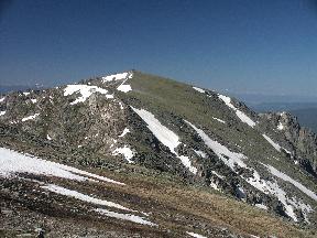
summit of Triangle Peak at 10:10.
"Triangle Peak" is a small, unnamed
summit on the Continental Divide at N 40o 21.570',
W 105o 45.830' and about 12,480' elevation. It looks triangular
on the map, and it looks triangular from all angles; it is easy to see
from Trail Ridge Road about 3/4 mile below Forest Canyon Overlook, just
to the left of Terra Tomah. I summit the peak to get a GPS reading;
one could just as well bypass the summit on the left (northwest) side.
|  |
|
I am a bit nervous about descending straight down from the summit,
since the rocks are fairly large, but it turns out to be a reasonable
route. The talus is large and hard to climb over; I soon decide
that the snow isn't too steep now and has a good runout, so I head onto
the snow and an easier descent into the valley, some 400 feet
of elevation below the divide. The valley floor is grassy and pleasant,
with a nice stream, which I reach at 12:00. The
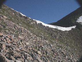
ridge between Cracktop and Julian
looks so bad from here that I'm amazed that I even attempted
it last year. I fill canteens and leave one of them to sit until I
pass by on the way back, taking two canteens with me. I cross
a few mild snow fields and reach the base of Julian at 12:40.
|  |
|
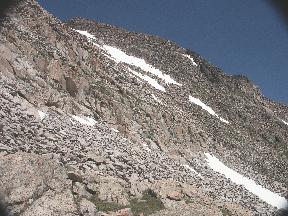
The climb up Julian is tough:
steep, large talus, often requiring
third-class moves. I reach the summit at 14:42, N 40o 22.272',
W 105o 45.457'. I have brought a small tripod for my camera
so that I can avoid hand shake and get some good photos, but it is so
windy that I fear the tripod would act as a sail and blow the camera away.
I take all the photos hand-held and hope that I don't blow away.
Gerry Roach says that Mt. Julian is seldom climbed; he's right.
The summit register dates from 1974 and shows that Julian has been climbed
by four other parties (seven people) in the last ten years. This is a
hike that requires self-sufficiency: the cavalry isn't likely to be
coming by any time soon. I call my wife on the cell phone and tell her
where I am, predicting a late return.
|  |
|
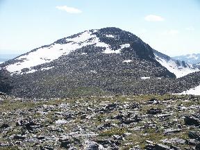
It's getting a bit late, but I decide to go ahead and climb
Terra Tomah;
I may not be back this way for quite a while.
The side of Julian toward Terra Tomah is more gentle. I leave the summit
of Julian at 15:20, reaching the base of Terra Tomah at 16:00. My feet
are beginning to hurt, and I stop and cut up a whole package of Moleskin,
trying to cover every pressure point on both feet; it's going to be a
long hike back. I reach the Terra Tomah summit at 16:35, GPS
N 40o 22.605', W 105o 44.895'.
|  |
|
The top of Terra Tomah
is so flat that I keep looking around to see if this little pile
of rocks is really the summit. After some searching, I find the summit
register: brass, marked NPS no. 13, half full of water. There are
a few slips of paper inside, whatever markings they contained long since
washed away. I write my name on waterproof paper and leave it in a ziploc
bag.
|  |
|
I leave Terra Tomah at 17:00, later than I would like. I need to make
good time to get back on trail before dark. I am hoping to bypass the
summit of Julian
on the left, crossing snow rather than rock and not
having to climb to the summit again. The snow may end in cliffs, but it
is at a mild angle; I use an ice axe self-belay but don't stop to put
on crampons. After the snow, I keep being forced higher, so that I wind
up missing the summit by only a few hundred feet. Going down, I head
to the right of the gully rather than the left side I came up; the talus
is smaller, and it certainly feels easier going down than it did going up.
|  |
I reach the valley floor, trying to follow my previous path exactly so
that I will find my canteen; I'm ready for some more water. I find the
canteen, fill another and drop in a treatment tablet, and head off
for my last climb of the day, the
re-ascent of Triangle Peak. I head up snow, again using an ice axe
self-belay but not crampons, then leave the snow for the rocks.
The summit keeps looking like it is just a hundred yards away; I go
fifty yards, and it still looks a hundred yards away. After many
repetitions of this, I finally top out on the divide to the right of
the summit. Now I can make some good time.
|
I head down the tundra, which gets increasingly steep and rocky,
toward the saddle of Nakai.
I reach the saddle at 21:00, and just after
I cross the snow, it is getting pretty dark. I go ahead and get out
lights: a Petzl Tikka LED headlamp and a tiny, but very bright, Pelican
2-AAA flashlight, with a CMG LED flashlight in my pocket as backup.
The LED headlamp is good to see where I am stepping, the flashlight
for father distances.
I always try to be on trail by 20:30, but this time I didn't make it.
I'm not comfortable going down loose talus and snow in the dark, but it
works out okay; I take it slowly. Toward the bottom, I am now faced
with finding my camping gear in the dark. After trying a few large
rocks, I find the right one. Some of the stuff has fallen down, but it
seems to be okay.
|  |
|
I head toward the upper Haynach Lake,
choosing what looks like the obvious
path. I soon find myself out on the end of a peninsula in the middle
of the lake. Nothing to do but go back, unless I want to swim. I decide
to go around to the left. After a few hundred yards, I come to a sign
with an unfriendly message ("No fires, no camping") but a friendly one
too: I'm back on trail.
|  |
Or so I think. The trail up here is so narrow and faint that it is
indistinguishable from game trails, and I soon lose the trail.
I decide to go on in the dark: the way is clear, down the valley,
and I must eventually
hit the Tonahutu Creek trail at the end of this valley. So I continue
with easy walking, and soon I pick up the trail again. This time I'm
going to be careful and not lose it; but I do. After several episodes
of losing and regaining the trail, it becomes larger and I pass the
two Haynach campsite signs. I follow the narrow trail carefully down
in the dark; it is a relief to hit the wide and clear Tonahutu Creek trail.
It's about 6 miles back to trailhead; I ought to be able to do that in a
couple of hours, right? Not in my present condition. My feet hurt from
constant pounding, my legs hurt from many steps uphill, and my shoulders
hurt from the pack straps. I feel like I'm walking fast, but my actual
progress is slower. Although I didn't notice it on the way, I now find
that the trail has many uphill sections; every uphill step is painful.
What idiot designed this trail, so that it is uphill on the way back?
My flashlight abruptly quits; it looks like a set of AAA batteries is
only good for two hours. That's okay; it got me through the difficult
part. Now that the trail is wide and clear, the LED flashlight is
good enough. I see an animal beside the trail, about the size of a
raccoon, but it doesn't look like a raccoon. It is slow-moving,
looking back at my LED flashlight. A badger perhaps? I can't identify it.
I decide to take a photo of it, but by the time I get the camera out,
the animal is gone.
Every 45 minutes or so I take a rest stop, eat a small Snickers bar, drink
some water. This trail is still hard work. I note the passing signs
for campsites and Granite Falls; each denotes progress, but they seem
slow in coming. I turn left and walk past Big Meadows. The trail
becomes wider, big enough for a pickup to drive on. The trail turns
right and heads west, straight for the road, and sometimes I think I
see a light at the end of the trail. At last I reach the trailhead at
02:53 on July 9, having taken six hours from the Nakai saddle.
It's after a hike like this that one can truly appreciate a car.
Now I just have to drive home over Trail Ridge Road without running off
the road. I am definitely tired and sleepy at this point, fighting to
stay awake. There is nobody else on the road at this hour, which is
good; at least I can't hit anybody. I occasionally start to nod off
and startle back awake. What remains of my conscious mind is telling
myself to ignore those things that are jumping at me from the side
of the road: they're all just hallucinations. I've seen a bumper sticker
that says "I brake for hallucinations", but when finally faced with
them, I'm deciding not to brake. Damn the hallucinations, full speed ahead.
I reach the edge of Estes Park and turn toward Marys Lake. If I can just
stay awake for 15 more minutes, I'll make it. I struggle to stay awake and
on the road, and finally arrive at the cabin at 04:30 -- almost 24 hours
since I got up at the Haynach campsite. I slip into the cabin.
I know my wife won't want me to crawl into bed smelling like I probably
smell, so I take off everything and put it in the washer, rip the
moleskin off my feet, and get into the shower. Then I can finally sleep.
After several failed attemps, I have finally climbed the elusive Mt. Julian
and Terra Tomah. Now when I look across from the Forest Canyon Overlook,
I can think, "Yeah, been there, done that. It was good."
Rocky Mountain National Park: The High Peaks