Mahana Peak
by Gordon S. Novak Jr.
June 30 - July 1, 2002
I had planned to climb Mahana Peak last year while climbing Isolation
Peak, but didn't do it: weather was closing in, and the clouds were
covering the tops of the mountains. Mahana Peak may not seem all that
exciting, but it's a climb I hadn't done. Perhaps I could go back a
different way and see some new country, maybe even climb Eagles Beak
as a side trip. The first part of the hike I know very well, having
been that way several times before.
|
I get a camping permit for the Upper Ouzel Creek campsite -- a lovely
aerie up on the mountainside above Ouzel Creek, described by a ranger
as the prettiest campsite in Wild Basin. My wife drops me off at the
Wild Basin ranger station, and I set off at 17:48 -- late as usual.
With some detours for photography, I get to
Calypso Cascades at 19:00.
The light snowpack this year has left Calypso Cascades a mere trickle
compared to usual. I take a few photos and press on.
|  |
|
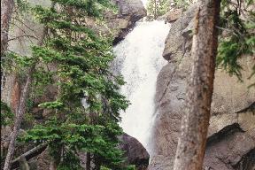
I reach Ouzel Falls at
19:30, leaving at 19:55. The trail above Ouzel Falls winds around the
ridge and then descends for a while -- unwelcome, because I know I'll
have to pay it back by hiking uphill on the return when I'm tired.
Soon the trail splits, with the left branch going toward Ouzel and
Bluebird Lakes, the right to Thunder Lake.
|  |
I go left, and the trail rises steeply to gain the top of a long ridge.
The ridge is rather barren, having burned
in the Ouzel Lake fire of
1978. Although there is considerable regrowth from the fire along the
trail to Ouzel Falls, there is less growth here. Lack of trees makes
it easy to see the mountains; it's like reaching timberline early.
|  |
I had thought I might detour to Ouzel Lake to take photos, but decide
against that now; the detour would take an hour, and it's getting late,
so I press on. It seems like I should be close to the campsite, but
I remember crossing a rock field and haven't done that yet. Of course
it takes longer to reach the destination than I expect. It is getting
dark, and still the trail goes on. Just as it gets really dark I see
the small sign for the campsite, and I head up the hill to camp at 21:30.
I usually camp in a rather Spartan fashion when hiking. No tent, no
stove, no pots; just an ultra-light 40-degree bag, OR "standard" bivy sack
(1.25 pounds vs. 8 pounds for a tent),
and a titanium spork (combination spoon-fork) for eating. I allow myself
the luxury of a 3/4 ultra-light ThermaRest pad. For dinner, I take a
tin of canned ham, bread, cheese, and some fruit. Breakfast is instant
Wheeties, breakfast of champions (fill a quart Ziploc freezer bag with
Wheeties, add 1 cup instant nonfat dry milk and 4 tbsp sugar);
I add water and eat it out of the bag with the spork. My backpack is
small and light (2 lb 14 oz), and I strap the camping gear on the side.
|
I get up at 07:10; it is again smokey from the many forest fires in
Colorado this year. I am a bit short on water and drink all I have
with breakfast; I plan to wait until well into the hike to filter more
to avoid carrying the weight uphill. I get on trail at 08:28 and reach
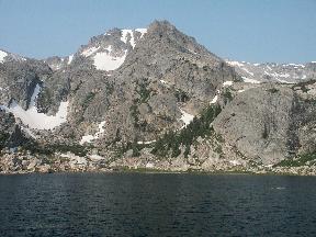
Bluebird Lake at 08:55. Bluebird Lake
is lovely and deserted.
|  |
|
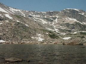
The route
leads up the ridge west of the lake to a high bench, then up the creek
to Lark Pond and Pipit Lake. Just below Pipit Lake
I filter 4.5 quarts
of water, drink 1.5 quarts of it, and carry 3 quarts. I leave Pipit Lake
at 11:30 and head north to Isolation Lake, reaching it at 12:48.
|  |
|
From Isolation Lake, the route is northeast
to a broad saddle between
Isolation Peak and Mahana Peak. From there, the summit of Mahana is
surprisingly close, and I reach the summit at 13:53.
|  |
|
Mahana is not
climbed often; the trail register, an antique brass cannister stamped
NPS no. 22, indicates that about 10 people have climbed Mahana in the
past two years.
|  |
|
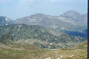
The view from the top is spectacular,
with unexpectedly
fine views of the premier peaks of the Park, as well as others that
are seldom seen. I take photos and leave at 15:10, reaching the saddle
again at 15:26.
|  |
|
I consider climbing Isolation Peak again, but it is too late for that.
I decide to go back via Eagles Beak, Eagle Lake and Box Lake, and the
Thunder Lake trail; this will take me over new territory and should be
interesting. Eagles Beak is plainly visible,
and striking in appearance,
almost a miniature Longs Peak. I head north toward it, curving left
around a ridge to reach Frigid Lake at 16:30, with Moomaw Glacier on
its far side and plenty of ice in the lake, and Eagles Beak on the right.
Gerry Roach's book says there is a third-class route up exposed ledges
on the back (west) side of Eagles Beak, but that is going to have to
wait for another day.
|  |
|
I leave Frigid Lake and head east before angling northward down the
ridge toward Eagle Lake. At the outlet of Eagle Lake, I see a broken
glass jar of salmon eggs left by some fisherman. The krummholz is dense,
and I choose what looks like the path of least resistance. Perhaps I
should have consulted the map more carefully at this point and headed
to Box Lake, which might have been an easier route.
|  |
|
I head down east of
the stream, sometimes through dense krummholz (don't want to break a leg
and get lost in this stuff), then down rather steep rocks near
Mertensia Falls,
finally crossing the stream and going west of it down steep wooded
terrain between cliff rocks to the bottom of the valley of the North St.
Vrain creek. I cross the creek on a log (or at least I think I do),
only to find many tributaries and swampy areas to be crossed on the
flat valley floor.
|  |
On the map, there is a bit of a climb from the creek up to the Thunder
Lake trail; in reality, it seems steep and much longer than I think
it should be. This should be can't-lose navigation: I am south of an
east-west trail, so if I go north I have to cross it. I use my compass
to ensure that I am going in the right direction and keep going and keep
going. My usual policy is to make sure I am firmly on trail by 20:30;
I don't mind walking back in the dark on a good trail. I still think
I'm going to make that deadline, though the trail seems elusive.
Then at 19:56 I see what looks like a trail, and sure enough, it is.
I try calling my wife on the cell phone to give her an estimate of when
I will get back. While the cell phone usually works (in analog mode)
from summits and from
Bluebird Lake, it doesn't work here, nor from Ouzel Falls, Calypso
Cascades, or anywhere else in the valleys of Wild Basin. As it gets
dark, I put on a Petzl Tikka LED headlamp, not too bright but adequate,
putting a small flashlight in my pocket as a backup. I get back to
the trailhead at 22:34, still unable to make a call. Some literature
says there is a phone at the Wild Basin ranger station. I see a woman
going into the ranger station and ask about a phone, but she says the
phone is for emergencies only and is none too friendly; she sees my
situation but doesn't offer use of the phone. So, having just
finished a hike of some 20 miles, I have little choice but to hike out
on the road. I trudge on for another two miles down the road, reaching
the Wild Basin Lodge at 23:30; there I find friendly people who let
me call my wife to pick me up.
Mahana Peak has been a great hike, one that deserves more visitors than
it gets; it offers solitude and outstanding views of the high peaks.
Rocky Mountain National Park: The High Peaks