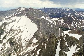
Mt. Richthofen is the highest peak in the Never Summer Range
in Rocky Mountain National Park. It provides great views of the
mountains in this range.
Mt. Richthofen can be approached either from Trail Ridge Road
or from the Lake Agnes trailhead, which is off Colorado Hwy. 14
a few miles west of Cameron Pass near the NW corner of the Park.
The Lake Agnes route is shorter and starts higher, but it is a
very long drive (3.5 hours one way from Estes Park, 2.5 hours
from Fort Collins). The trailhead is in a State Park area that
requires leaving a $4 fee in an envelope.
|
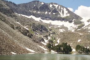
Although I got up at 6:00, I don't leave the Lake Agnes trailhead
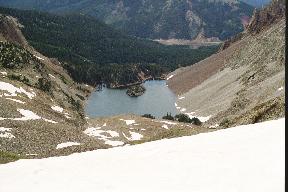
until 11:00 due to the long drive. Lake Agnes is a bit less than a
mile up the trail. The lake has a rock island in the middle. The
left side of the lake is a landslide of loose rock falling down from
the Nokhu Crags; different color bands of falling rock make for an
interesting appearance. Mt. Richthofen
and the route up are easily visible from the lake.
I start around the right side of the lake to avoid the rockslide
area on the left. There is a trail around the lake for the most
part, but for about 30 yards, below some cliffs at the edge of the
lake, the trail vanishes below the water. I consider wading (but the
rocks look too sharp for bare feet and I don't want wet boots this
early in the hike), carrying rocks to extend the path, or climbing
above the cliffs. I choose the latter, which turns out to be some
of the steepest and most exposed climbing of the trip.
|  |
|
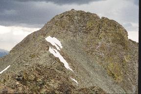
Once around the cliffs at 12:30, I head up rather loose medium-sized
talus (1-2 feet) and then moderate snow, using crampons, to a saddle
between Mt. Richthofen and an unnamed peak. The snow is easier
climbing than the talus; I reach the saddle at 13:20. From here the
way is clear: up scree to a shoulder, traverse the shoulder, then
up a final couloir to the summit. The scree is terrible. Although
the rock is hard, it is highly fractured into small pieces, and
everything on this slope seems loose. Even large rocks are liable to
slide down onto you if you disturb their tenuous supports.
Sometimes a step up causes so much downslide that you lose altitude.
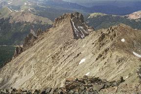
After reaching the shoulder, the slope is more moderate, and the route
goes along a ridge line a couple of feet wide. The ridge is not
really exposed, although both sides are steep slopes covered with
loose rock. Finally there is a more peaked
summit area.
|  |
|
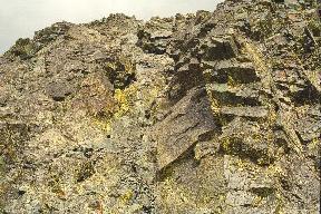
The summit climb is up a steep couloir
at about 45 degrees. The couloir has good hand and foot holds,
although it does contain some loose rock. I reach the summit at 16:50.
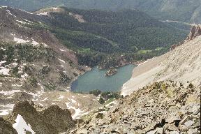
The summit is rather small, with a semi-circular windbreak containing
the summit register, and not room for much else. I see that the
climbing register was placed by Greg Martin, with whom I hiked a few
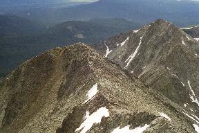
years ago. There is a clear view
down to Lake Agnes and interesting
views of surrounding peaks in the
Never Summer Range.
|  |
 |
 |
|
I had planned to climb Static Peak
too, but it is getting late, I am
tired, weather threatens, and I have no desire to be strung out on
an exposed ridge toward something called Static Peak in a lightning
storm. Time to go home; I leave at 17:10. It isn't immediately
obvious how to get down from this narrow perch; luckily I remember
an unusual layered rock from the ascent, and that guides me back into
the couloir. I descend over the ridge
of the shoulder and start back down the
scree. Many steps cause a slip; I fall a few times and cut my hands
on the sharp rocks,
though not badly. Occasionally a rock goes flying and makes a sound
exactly like a dinner plate dropped on a hard floor. I get back to
the saddle at 18:15.
From there, I try to stay on snow as much as
possible, having had enough of loose rock. I get back to the lake
at 19:15. This time, I take my socks off, put the boots back on,
and wade back through the lake below the cliffs. I get back to
the trailhead at 20:17 for a long drive back home: 8 hours total
driving today in addition to the hike.
|  |
 |
 |
Mt. Richthofen is an interesting and exciting hike; although it is
just under 13,000 feet, it truly feels like a big mountain.