
I plan to leave no later than 3 PM, but cabin repair chores keep me busy, and I leave trailhead at 15:48. That should still get me to a campsite before dark. Since Elk Tooth is about 8 miles from the nearest road, I plan to camp close to it to get an early start. I have gotten a camping permit for a cross-country area southeast of Pear Lake. Despite my plans to reach camp before dark, photo opportunities arise, including a snowshoe hare -- the first one I've ever seen. I leave Finch Lake at 19:35, arriving at Pear Lake at 20:30.
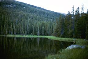
I am planning to camp near Lake 10852 (identified on the map only by its altitude), about half a mile southeast of Pear Lake. There is a trail around Pear Lake, in fact many of them; I try to follow the best one, but wind up doing fairly easy bushwhacking, passing an intermediate small lake and coming out near Cony Creek. So where is my Lake 10852? I finally decide it is below me, so I head down the hill just as it gets completely dark, stumbling through the heavy timber looking for a level campsite. I find a place behind a log, the requisite 200 feet from the lake and beside but not in a meadow, and make camp at 21:35.

I get up at 07:35 and get started hiking by 09:00. I hike back up to Cony Creek at the base of Elk Tooth. Since this is the last water source for a while, I filter water to fill my canteens. I am feeling dehydrated, so I pump 4.5 quarts and drink 1.5 quarts on the spot, taking 3 quarts up.
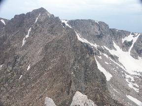
I start up the mountain at 11:05. My route goes below two snow patches, with a bit of rock scrambling at the edge of the second one to avoid the snow. I cache my sleeping bag, pad, and bivy sack behind a big rock; no need to carry them up the mountain. There is a small hourglass of loose rock spilling through a break in a cliff band; it looks like a possibly viable route, so I head toward it and get up with a bit of rock scrambling. Then I head up towards a rock that looks like a conifer tree, then up to a shoulder to the east of the summit. After a bit of climbing on this ridge, it looks like I may be reaching the summit. Is this really it? I wish!

When I top out at 13:40 on what I hope is the summit, though, it is clear to me that this isn't really it. There is a dramatic cliff to the west, and surely that is the summit. Somebody has left a trail register on this summit in a glass jar, and has signed it with a note that they think this is the Elk Tooth summit. I sign the register, but add a note that I don't think this is the summit. The summit is that big, nasty cliff to the west. This is hump number 1 of a 4-hump camel, and the summit is the last and biggest hump. Here the GPS says 12,772', N 40o 10.071', W 105o 38.992'.
It's getting late in the day, and the weather to the west is looking bad. I'm doubting that I can make it to the top given that weather. I call my wife on the cell phone and tell her where I am, and say that I will probably turn back from here. Then I eat a snack.

After I've been sitting on this minor summit for a while, the weather still looks bad, but no worse than it did a while ago. It would be a shame to hike all this way and miss the summit. I wonder if I could perhaps go a little further, so I do. The ridge is rough and requires some class 3 scrambling, but it isn't too exposed. I bypass one hump on the south side (rather than the north side the books recommend), otherwise staying on or just north of the ridge line. The weather still looks bad, but no worse, so I continue. Before long, I am at the final summit ridge, so I make a quick push and reach the summit of Elk Tooth at 14:30.

There is a dramatic view of Ogalalla Peak. The GPS reads 12,787' (map says 12,848'), N 40o 10.066', W 105o 39.308' . There is a trail register in heavy PVC pipe, secured to the rock by a 1/4" galvanized steel cable -- or at least it used to be: the cable is broken. Apparently a heavy steel cable is no match for winter winds and metal fatigue. I sign the register and wedge it back deep between rocks where I found it. Judging by the trail register, about 22 people per year climb Elk Tooth.
Off to the north is a good view of the southern Cony Express couloir, which I used to climb Ogalalla a few years ago.

I leave the summit at 15:05 and head down the eastern ridge where I came up. The weather still looks bad nearby, but it never gets bad where I am. I am tempted to head straight down the side of the mountain, which looks like an easier route, but I never can convince myself that I can see talus going all the way to the bottom. If there is a cliff band in the middle, it wouldn't be a shortcut; so I wind up going back the way I came up. Looking back at photos after my return, it looks like I made the right decision; going down earlier would probably have led to cliffs.


