

| Stones Peak is a massive mountain that dominates the valley of Moraine Park; it forms the left end of the group of mountains seen across from Forest Canyon Overlook on Trail Ridge Road. It isn't hard to climb; it's just a long way from anywhere, about 20 miles round trip. The guidebooks call it "a long day", quite an understatement! I leave Bear Lake at 07:40 and reach the summit of Flattop at 10:54; temperature 42 F with a strong NW wind. | |
| I head north on trail across Bighorn Flats. A few miles from Flattop I meet two Austrians hiking the Big Meadows trail. As I approach Sprague Pass, a herd of about forty elk is grazing peacefully on the tundra grass. These are big animals, and this is their territory; they could trample me to bits if they wanted. But the whole herd flees well before I get close. I reach Sprague Pass at 12:55. Snowdrift Peak is aptly named, very snowy on this side. | |
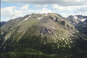
| I reach the summit of Sprague at 14:37 and then traverse the ridge that connects Sprague with Stones. This is called Class 3 in the guidebooks, but it seems like an awfully exposed Class 3 to me; perhaps I should have stayed directly on top of the ridge. The route then descends some 500 feet before climbing up tundra to the summit of Stones Peak. There are great views of Hayden Spire (the sharp peak across from Forest Canyon Overlook) on the left. | |
I reach the summit of Stones at 17:35 -- pretty late in the day. There is only an unofficial summit register in a mason jar. A lower, unnamed second summit of Stones is an easy mile away, but it is too late for that; it will have to wait for another time. I am pretty tired. I leave the summit at 18:00.
The prospect of descending 500 feet, then re-climbing Sprague and making a long, slow trek back the way I came is decidedly unappealing. The valley below, Spruce Canyon, looks gentle and green, rather like the valley between Mt. Meeker and Mt. Orton, which is very nice hiking. Perhaps I could descend into the valley, follow the creek down and bushwhack over to Spruce Lake, and then hike out on the Fern Lake trail; after all, the guidebooks list this as one of the routes up Stones. I check out the valley with binoculars; it looks like easy hiking for as far as I can see. I decide to go that way; it might even be faster.
The descent into the valley is steep and takes longer than I expected, but I make it down safely to Hourglass Lake at 20:08. Once I reach the bottom of the valley, the hiking is indeed nice and fast throughout the area I had seen from the summit of Stones. After that, though, Spruce Canyon presents a devilish series of trials.
First there is a swamp; I get through it without getting too muddy, but it slows me down. Next is a snow hump in the middle of the valley, like a giant loaf of French bread 20 feet in diameter. At this time, all of the snow is gone thousands of feet higher than the valley floor, but in shaded conditions lots of snow has survived here. I put on crampons to avoid slipping off the sides of the hump.
The next trial is a field of giant boulders. When the boulders are the size of bathtubs, you can hop between them; but when the boulders are the size of cars and houses this is no longer possible. I am reduced to a little mouse trying to find a path over, around, and between the boulders.
After the boulders, the canyon narrows; the stream is bordered on the north by cliffs as it plunges more steeply down, and it is covered by a layer of snow. The snow would be easy walking, but I dare not go that way, since I could easily fall through into the creek and perish by hypothermia. The other side of the river is a maze of waist-high thick krummholz, densely twisted and intertwined trees that are very difficult to get through. As I start into the krummholz, it rather suddenly begins to get dark.
Clearly my shortcut has been a mistake. It will not be possible to negotiate Spruce Canyon in the dark, even with a flashlight. I am not in any danger; the weather is mild, and I could simply rest where I am until morning. However, I know that my wife will get worried and probably call out the rangers to look for me, and I don't want that to happen.
I decide to try to climb the south side of the canyon to regain the plateau of Bighorn Flats. By flashlight, I climb up steep and usually loose talus until I hit cliff bands just below the top of the canyon wall. I find a place that looks climbable and climb part way up it, but as I get higher the exposure increases, so I come back down. Finally I find a class 3 route that puts me on top, somewhere near the summit of Gabletop, at 01:00.
I have a portable CB radio, so I try to make contact with someone to call my wife and tell her I am okay, but get no response. Flattop Mountain should be two miles of tundra due south, and then I can go down the Flattop trail. It is a long, dreary, somewhat uphill trudge. After a while I think I might have gone too far; it is easy to get disoriented on Bighorn Flats when visibility is low because it all looks the same. But no, I still have a way to go. I finally reach the summit of Flattop at 03:00 and start down. The lights of Estes Park are beautiful as the dawn breaks.
I reach the Bear Lake parking lot at 05:20 -- after 21 hours and 40 minutes of continuous hiking. I think I will stop at the entrance station and tell them I am back so that no search party will go out, but the entrance station is closed. I call my wife from Estes and proceed on home.
Sure enough, my wife has called the rangers. (This was not easy; she called 911 and got a lowland 911 operator who had never heard of Bear Lake! "What road is it on?" Bear Lake Road. "I don't have any listing for Bear Lake Road.") The ranger checked the parking lot and found my car, but waited before going out to look. I call the ranger to report that I am back, telling him I appreciate his efforts and am very sorry I have cost him some sleep. He asks me what happened, and I tell him the story. "So what made you think that an east-facing valley would be a good route?" he asks. I lamely say it reminded me of the nice valley between Meeker and Orton (which, it then occurs to me, is a south-facing valley), and the Dannen guidebook had recommended it as a route. [Later I check the most recent edition of the Dannen book; it now has few nice things to say about Spruce Canyon. Somebody must have written them a letter and complained.]
Lessons learned: